According to the weather forecasters, we were going to be getting rain in the afternoon and the morning would be cloudy. Pulling up to the top of Lime Hollow Road, I got my first view of the rising sun, silhouetting a large tree. I was heading over to pick up Ann Marie, we were going to take another ride in the country. We were heading south, towards Ohiopyle.
Our trips seem to always follow a certain “outline”, with-in the first half hour we stop for fueling; coffee and something to munch on. This day was no different. Fueled, we hit the highway, and then onto two lane roads, aiming first for Latrobe.
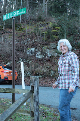
As per our outline, we usually have a couple geocaches to find. The first search of the day brought us to Fred Rogers Drive.
If you look at the picture closely you can just see the cache hanging on the sign. Thinking of Mr. Rogers, it was truly turning into a beautiful day in the neighborhood! The skies were blue and there was no lack of sunshine. AMB quickly found the cache and three of the other four caches we looked for. I found the other one mainly because it was on my side of the car.
We drove through the outskirts of Ligonier, passing beautiful snowy horse pastures and then through Donegal and over to Normalville where we then dropped down into the valley. Taking a few smaller roads, we eventually came to the remains of the Fayette Furnace.
Sitting not far from the road, it is easily seen during the winter season when all the leaves are off the trees. It is a large looking furnace with two very large openings in it. It could be due to the size of the arches that make it appears so large. The side facing Bucks Run has collapsed, possibly due to the centuries of high water washing against it.
The three remaining sides all have large cracks forming in them and there are a few trees growing on it. Trees can be very destructive as their roots force the stones apart.
There are conflicting dates as to when it was built. The book I consulted, A Guide to the Old Stone Blast Furnaces of Western Pennsylvania, by Sharp and Thomas says it was either 1815 or 1827. There were 30 to 50 people who worked here. It produced about 500 tons of iron a year and went out of blast in 1840. It was a productive community. It is difficult to imagine when you look at the ruins, all that is here, is the stone stack!
We managed to find some paths through the ever present “jagger” bushes and were able to get close to it. Neither of us got any scratches or cuts!
From here we headed north following the road we took to get to the furnace. This took us into State Game Lands and across a couple mountains. This sounds easier than it was. The roads had been plowed but were covered with a layer of packed down snow. Some of the steeper hills had been cindered. We would slowly work our way up the hill only to reach a spot where you couldn’t see what was below us, slowly we would creep forward until we could see where we were going. Luckily, we only met one other car while we were on these tight dirt roads. Coming to the start of one hill, we decided to turn around rather than chance it. Luckily there was a spot wide enough to turn around, most of the roads were only wide enough for a car to pass through. The edges were either ruts or piles of plowed snow. We chose another road and hoped for the best, we were following the compass most of all, when we came to an intersection, we kept heading towards the north.
We went down a couple hills holding our breath, hoping that the conditions wouldn’t deteriorate and that we wouldn’t slide. The ride was worth it though; we saw some nice views from the top of the hills not to mention some beautiful Pennsylvania woodlands. A half hour or so later, we finally came to a paved road. We were only a few miles away from where we were heading!
The final find of the day was in Laurel Hill State Park. It was a Multi-cache, meaning that we had to find a cache and then by doing some basic math with what we found in it, we would figure out the final location. It ended up being about a ¼ mile away, across a snow covered field. “We can do that!”, so off we went.
The snow had a crust on it and so we had to break through it every step. In places the snow was 6 inches or higher. Ground zero was in some woods and the GPS signal bounced around a lot. We went back and forth and finally got it down to a 60 foot circle. The snow made it even harder to find, we checked all the “usual” spots such as stumps and logs but almost all of them had snow packed around them.
Ann Marie finally found it under a fallen tree. She said she just happened to glance in the right direction at the right time and saw a corner of it. I believe it was her superior "geo-sense" that led her to it!
From there we stopped in Mt. Pleasant for a late lunch and then headed back home. As we neared Pittsburgh the sky started clouding over, which was fine with us. The day was great as far as we were concerned. One lesson that was learned, or maybe re-enforced was, don’t trust the weathermen, just open the door and look for yourself!


.jpg)


1 comment:
Another fun adventure. I would have liked to been along.
Post a Comment