Showing posts with label geocaching. Show all posts

Thursday, May 22, 2025

100000 Miles and Then Some


It wasn’t the first time that Frank and I started a trip in the rain. We never let a few raindrops keep us from having a good time. Frank had arrived early, and we were on the road by 5:30. The rain continued to come and go as we drove north.

    We stopped for a coffee in downtown Butler but were over an hour early. The shop hadn’t opened yet. We continued on to Sheetz. Their coffee is always hot and delicious. They have nice clean bathrooms also, something I always remember when I’m on the road!

    As is always the case, along with photography, geocaching was included on the itinerary. We found just over half of the ones we searched for, not our best day but we weren’t complaining.  The rain tapered off when we were outside of the car searching; still I was happy that I had worn my wide brimmed hat.


    While none of the caches were difficult, they often brought us to some beautiful areas. We visited a few streams, the water on the grass and fresh growth made everything thing look bright and vibrant. The reflections in some of the streams and the sounds of the water flowing over the stones in them gave me a feeling of freedom. All my worries and cares drifted away with the water. Some of the fields were covered with yellow flowers giving them a yellow tinted blanket. Purple and white flowers lined the roads, the rain glistening on them; it was great day to be out.


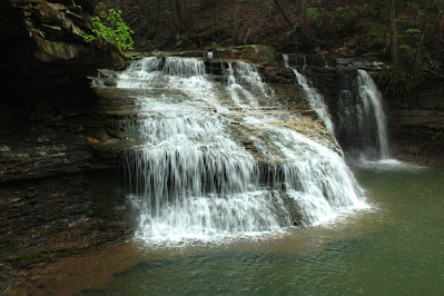
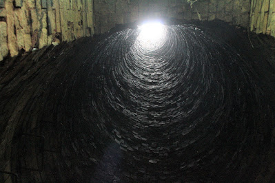
    Freedom Falls on Shull Run could be heard from where we parked the car. The trees overhead helped keep some of the rain off of us but my coat was drenched by the time we returned to the car. Besides the falls, we also made a quick visit to the old iron furnace stack located just downstream.

    The rain added to the flow coming over the falls. At its base the water was clear showing the depths of the pool below. During other visits we have seen swimmers here and chances are that this coming Monday, Memorial Day, there will be some here enjoying both the cool water and the sounds it makes as it rushes over the edge.

    We stopped and watched heavy equipment working in a pit on the side of the road. Deep in the ground they looked like Tonka toys from where we stood.

    We drove through lots of small communities filled with small houses. In many of them we saw the older houses on the fringes, sometimes overgrown and even forgotten. I wonder what happened to the people who lived there, did they move, was it health problems or maybe they have passed away. Some are extreme with vines growing up their sides, the decorative landscaping of the front yards overgrown and trying their best to hide the house from view, toys and tools rusting away in the yards. In some cases the houses are barely standing. A few years from now, they will be lying on the ground, gone from both sight and memory.

    Our trip took us through the town of Franklin, the county seat of Franklin County. It is a beautiful town with a nice collection of restaurants and shops. A stop was made at the Iron Furnace Coffee shop, it seemed appropriate.  I couldn’t pass up getting one of their tee-shirts. Celebrating two of my interests, coffee and iron furnaces, it was great. All it needed was a mention of books on it and I’d be over the edge.

    Heading south on rt.8, we stopped to look at a heron rookery. Turkey buzzards were flying around the area and we could see herons standing on their nests watching them, perhaps guarding their offspring.

    A mile further and we pulled over to the side of the road. This would be our last planned stop, the Victory Iron Furnace. We loaded up with our camera gear and dropped down into the woods. We had to crawl over a deer fence but there were several spots where it had collapsed, making it easier for us. Working our way down the steep hillside into the valley we encountered a few downed trees which blocked our passage. Other than these detours, getting to the stream at the bottom was fairly easy. The stream, Victory Run, was our next obstacle. Last time I was here it was shallow enough that I could hop from rock to rock to get across. The recent rain had swollen it. 

    Did I mention that a little rain never held us back? The water was only a little over my knees!


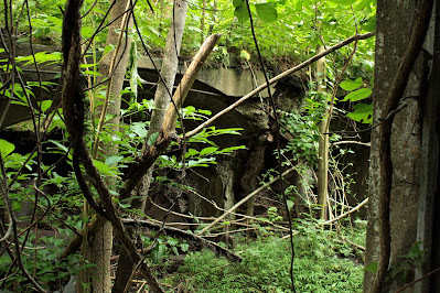
    The furnace is only visible when you near it. The flat area in front of the stack, where the casting house used to stand, is filled with trees, weeds and jagger bushes, effectively hiding it from sight.

    This iron furnace was only in operation for about 7 years.  Built in 1843, the Victory Furnace was built up against a high hillside. Many furnaces were built like this to ease putting the various materials that make iron into the top of the furnace.

     I found a piece of slag on the ground near-by. Slag is a byproduct of the iron making process. Impurities float to the top of the molten iron. It is removed from the furnace before the iron is cast. Slag can be found near any old furnace. The piece I found was probably over 175 years old. Bits of un-burnt charcoal and wood can be seen in it.

    As with most of Pennsylvania’s iron furnaces, almost everything that once stood here is gone. A flat area on the hillside above the furnace was where the charcoal house once stood and the level remains of a road can be seen in places, now traversable only by foot.

    The trip across the stream and up the hillside to the car was uneventful though we were both happy to be back.

    Almost 20 miles further down rt.8 we came to a spot I had been looking forward to all day. My odometer turned over to 100000 miles! I don’t know the reason why but I always enjoy watching and noting things such as this. I can remember as a kid watching my watch as the date changed. It doesn’t always change right at midnight! I guess it is a human condition, a variation of birthdays and New Years Eve parties. I had to stop and take a picture!

    We arrived back at my house 9 hours after we left. Both of us felt pretty good after that amount of time in the car. I’m looking forward to an even longer trip soon across the state!

    Heavy thunderstorms descended on my house about an hour after we got home. With news reports about heavy rain and a tornado in some of the areas we had traveled through, it seems that once again we had timed things just right! I have to add, it sure felt good getting out of my wet clothes and into a hot shower!


Saturday, January 13, 2024

Always Trust the Weathermen?

 According to the weather forecasters, we were going to be getting rain in the afternoon and the morning would be cloudy. Pulling up to the top of Lime Hollow Road, I got my first view of the rising sun, silhouetting a large tree. I was heading over to pick up Ann Marie, we were going to take another ride in the country. We were heading south, towards Ohiopyle.

    Our trips seem to always follow a certain “outline”, with-in the first half hour we stop for fueling; coffee and something to munch on. This day was no different. Fueled, we hit the highway, and then onto two lane roads, aiming first for Latrobe.

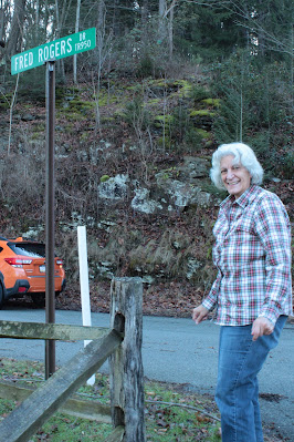
    As per our outline, we usually have a couple geocaches to find. The first search of the day brought us to Fred Rogers Drive.


    If you look at the picture closely you can just see the cache hanging on the sign. Thinking of Mr. Rogers, it was truly turning into a beautiful day in the neighborhood! The skies were blue and there was no lack of sunshine. AMB quickly found the cache and three of the other four caches we looked for. I found the other one mainly because it was on my side of the car.

    We drove through the outskirts of Ligonier, passing beautiful snowy horse pastures and then through Donegal and over to Normalville where we then dropped down into the valley. Taking a few smaller roads, we eventually came to the remains of the Fayette Furnace.


    Sitting not far from the road, it is easily seen during the winter season when all the leaves are off the trees. It is a large looking furnace with two very large openings in it. It could be due to the size of the arches that make it appears so large. The side facing Bucks Run has collapsed, possibly due to the centuries of high water washing against it.


    The three remaining sides all have large cracks forming in them and there are a few trees growing on it. Trees can be very destructive as their roots force the stones apart.

    There are conflicting dates as to when it was built. The book I consulted, A Guide to the Old Stone Blast Furnaces of Western Pennsylvania, by Sharp and Thomas says it was either 1815 or 1827. There were 30 to 50 people who worked here. It produced about 500 tons of iron a year and went out of blast in 1840. It was a productive community. It is difficult to imagine when you look at the ruins, all that is here, is the stone stack! 

    We managed to find some paths through the ever present “jagger” bushes and were able to get close to it. Neither of us got any scratches or cuts!

    From here we headed north following the road we took to get to the furnace. This took us into State Game Lands and across a couple mountains. This sounds easier than it was. The roads had been plowed but were covered with a layer of packed down snow. Some of the steeper hills had been cindered. We would slowly work our way up the hill only to reach a spot where you couldn’t see what was below us, slowly we would creep forward until we could see where we were going. Luckily, we only met one other car while we were on these tight dirt roads. Coming to the start of one hill, we decided to turn around rather than chance it. Luckily there was a spot wide enough to turn around, most of the roads were only wide enough for a car to pass through. The edges were either ruts or piles of plowed snow. We chose another road and hoped for the best, we were following the compass most of all, when we came to an intersection, we kept heading towards the north.

    We went down a couple hills holding our breath, hoping that the conditions wouldn’t deteriorate and that we wouldn’t slide. The ride was worth it though; we saw some nice views from the top of the hills not to mention some beautiful Pennsylvania woodlands. A half hour or so later, we finally came to a paved road. We were only a few miles away from where we were heading!

    The final find of the day was in Laurel Hill State Park. It was a Multi-cache, meaning that we had to find a cache and then by doing some basic math with what we found in it, we would figure out the final location. It ended up being about a ¼ mile away, across a snow covered field. “We can do that!”, so off we went.

    The snow had a crust on it and so we had to break through it every step. In places the snow was 6 inches or higher. Ground zero was in some woods and the GPS signal bounced around a lot. We went back and forth and finally got it down to a 60 foot circle. The snow made it even harder to find, we checked all the “usual” spots such as stumps and logs but almost all of them had snow packed around them.

    Ann Marie finally found it under a fallen tree. She said she just happened to glance in the right direction at the right time and saw a corner of it. I believe it was her superior "geo-sense" that led her to it!

    From there we stopped in Mt. Pleasant for a late lunch and then headed back home. As we neared Pittsburgh the sky started clouding over, which was fine with us. The day was great as far as we were concerned. One lesson that was learned, or maybe re-enforced was, don’t trust the weathermen, just open the door and look for yourself!


Saturday, October 7, 2023

Going to the Maps


I had just finished reading “The Cartographers” by Peng Shepard and was thinking about it. It was about maps and how they have the potential for making places real. While the book was about using a map as a key to entering a place no one else could go to unless they held the map, I’ve always thought that maps made things real to us. By showing us the way to go, we can experience places that we’ve only heard about.

    Every time I go on a trip, or even think about the possibility of going on one, I go to my maps. Atlas’s, gazetteers, simple folded gas station maps, (remember those?) and even the simple to use, internet maps, I use them all. Looking at them I can decide which routes to take, I can determine whether it will be a quick speedy journey or a scenic one. I can find places to stop and places where things can be found and uncovered. Maps are as important to me as my books are!

    I recently saw a picture of an old furnace that someone had posted. My curiosity piqued, I pulled out my reference materials.

    The first step was to check a book I have about iron furnaces. Published during the second half of the last century, A Guide to the Old Stone Blast Furnaces in Western Pennsylvania, written by Myron Sharp and William Thomas, has been invaluable to me, helping me find numerous old furnaces. Some were mere piles of rock, a few were empty fields or parking lots but there have also been a lot of exciting structures found. Some are hidden deep in the woods, inaccessible to anyone except those who don’t mind a bit of discomfort in their exploring. Some are sitting in plain sight beside the road. This book has taken me to numerous furnaces which while being over 100 years old, still show the mastery of the men who put them together!

    With a little more information about the furnace, I turned next to my Pennsylvania Gazetteer and tracked down the roads mentioned in the book. I also checked a couple other books I have to see if there was any mention of the furnace in them. I added more notes to my list and then I moved into the present century and the computer.

    I visited a favorite search site called Waymarking.com. They have a category called Iron Furnace Ruins which consists of seven pages of furnaces located around the world. I quickly found the furnace I was thinking about going to and clicked on it. I was presented a couple pictures and a GPS location! I copied them all. I put a mark on a map indicating where it was located.

    With Google Maps, I had a good idea of what the countryside looked like, the satellite view showed me near-by road marks, places which would help keep me on track.  On-line topographic maps helped me see what kind of hills and valleys I might encounter.

    I also searched the maps on Geocaching.com to see if there were any hides in the area. A new cache had been listed at a site that I had visited before, near another iron furnace. Located with-in 10 miles of the other, as the crow flies, I added it to the list also!

    I compared maps and made a route which would take us on a nice, scenic route, making sure to pass a few geocaches on the way. I avoided any toll roads and we would only take one expressway for about 5-10 miles. The ride would be an enjoyable one!

    On Thursday morning, I had my gear packed in the car and was enjoying a cup of coffee when Frank arrived. A bit earlier than planned but that was expected, neither of us has a problem with early starts. We hit the road well before the sun rose. Our first geocache was found with the aid of a flashlight. Soon after, the sky in the east started showing its colors.

    We made a brief photo stop at the Country Kitchen, its egg showing up nicely in the predawn light. A couple caches later, we hit route 80, just a little after 8. The slanting sunshine of the morning gave the trees even more color, making the ride a visual experience.

    We were getting closer, the Alleghany River had a slight covering of mist on it as we crossed it into Emlenton, then we headed back up out of the river valley to the hill tops.

    We found another cache less than a mile away from the furnace. Hidden on a small open grate bridge, it gave us another opportunity to get out and stretch our legs as we were looking. We signed the log and re-hid it and then drove another quarter mile where we encountered a gate. Parking here, we slung our camera gear over our shoulders and proceeded on foot. The trail was a gravel/ dirt road, going on a slight uphill slant before dropping down into the valley. Going down, we could see the road leveling off ahead of us and as we rounded a curve, our GPSs told us we had arrived.

    A slight rise in the surrounding weeds was all we could see, the sunlight coming from behind the furnace further hid the structure from us. We took a “path” which led towards where we thought it would be. As we pushed through waist high weeds and crossed over hidden fallen trees the stones of the structure started to appear to us.

    Surrounded by the weeds and bushes it was hard to get a whole view of the furnace. Vines grabbed at our feet and thorns tore at our clothes and skin. We couldn’t see where we were planting our feet, we could only guess and hope.


    Finally, there it was, the Webster Furnace. It was built back in 1838 and operated for an unknown amount of time. It went out of blast when the owners went bankrupt. What makes this furnace exciting is that the base is square like most furnaces, but the top portion has an octagonal shape covering the chimney, an eight-sided top!

    The furnace is in fairly good shape but trees have grown on top of it and their roots are slowly pushing the blocks apart, leading to its eventual demise. The underbrush made it difficult moving around it and seeing anything such as a mill race or walls, if there were any.

    After my photographic lust had been quenched, we packed up and started back up the hill. It was only seven tenths of a mile but it seemed to me to be further on the way up!

    We drove through the picturesque town of Franklin and stopped for two more caches before heading back towards home. The first was a failure; we couldn’t locate it and after a few minutes, continued on the final cache. Sometimes you’re lucky and sometimes, you just strike out…

    The second cache was great, in my opinion. We parked alongside the road and had to crawl over a deer fence. This put us at the top of a semi-deep valley. Most of the hillside was steep but there were a couple ramps which allowed access. Crossing a small stream, the furnace slowly revealed itself, sitting among the yellow fall leaves, hidden in plain sight.


    This was the Victory Furnace, built in 1843 and worked for about 7 years before it went out of blast. It is a nice tall furnace, the edges still sharp and square but it does have a few big cracks in it, one large one going up its front. I passed some cut rocks as I approached, possibly from the millrace or some other structures. There are supposedly ruins of the charcoal house on the hill behind it, I didn’t climb up to see but the idea of another trip has started to grow in my mind! Perhaps when the leaves have fallen and the sight lines are better.

    This wasn’t the first time I had visited the Victory Furnace. My first visit was because of another geocache. I stopped here early in the morning on a cool fall day in 2008. The valley was filled with fog and the sun was just rising, the area was dark, but that wasn’t going to stop me. It was a day that caused my imagination to wander.

    At the bottom of the hillside, I came to the stream. It had steep banks and I had to look around to find a place where I could get down to the water level. Splashing across the shallow stream, my GPS showed the cache only 50-60 feet away. Scrambling up the steep bank, the furnace revealed itself to me. Coming out of the fog, it resembled an ancient temple, much like in an Indiana Jones movie. With my heart beating and adrenalin pounding through my veins, I made my way through the fog and the weeds to the base of the furnace.

    Sitting alone in the valley, it appeared as if it had been dropped here. There were no roads or trails that I could see and no signs of any other ruins near-by. It was a mystical experience and the worst thing about it was that there was no one with me to share it with. It was one of those days that I’ll never forget!

    After spending some time finding the cache and taking pictures, Frank and I re-climbed the hill and returned to the car. In my mind, this was the best cache of the day! In another hour (or so) we were back at my house. Frank continued on to his home and I went in to change out of my dirty clothes and look for ticks. (none found!)

    I looked at my pictures and got a bite to eat and then sat down and started thinking…when could I go back to that last furnace?  

  I already have the maps…


Friday, September 22, 2023

Going to the Follies

 It was Thursday morning and the weathermen were gushing over what a nice day it was going to be. Officially, there were only three more days of summer left. Listening to the radio as I lay in bed, willing myself to get up, I decided to take a walk and I knew exactly where I was going to go.

    An hour or two later I was driving down a narrow neighborhood street in Highland Park. I pulled in-between two cars parked along side of the road and got out. I slid my camera gear over my shoulder and turned on my GPS. Locking the car, I walked over to a barely noticeable path leading into the woods and stepped in.

    Dropping down into a valley, the trail starts out on a set of brick steps with a thick handrail beside them. A finial sits atop the metal post at the bottom, giving credence to it being built many, many years ago. Putting nice finishing touches on things such as these are rarely done these days.

    There used to be a sidewalk at the bottom of the steps, it has since washed away with only occasional pieces of brickwork scattered across the steep slope. The pathway goes around theses remnants rather than across them, the angle they sit on makes them unsafe and also, unnecessary.

    Passing a small spring, I maneuvered around a fallen tree. The well-worn path showed me the way. After this, the trail leveled off, to one side was the drop into the valley and to the other, a steep hillside filled with tall weeds. I rubbed across a bush and was rewarded with some swollen bumps which thankfully, itched rather than stung. I nearly grabbed a thick stalk for balance when I realized that it was covered with thorns and sharp needle-like hairs. Luckily, I pulled my hand back before I touched it. The path was mainly dirt but there are numerous large stones imbedded in it, the hillside is covered with them. A careful eye was needed to avoid tripping.

    It wasn’t a long walk and the day was perfect for it. The trees kept the sunshine off of me and kept me cool. Spots of sunshine slipped through the trees illuminating the batches of white snakeroot and pokeweed covering the slopes. The sounds of cars had disappeared, there was no one around and even the birds seemed quiet, it was a peaceful and relaxing setting.

    I passed under a low hanging bush and saw what I had come to see. Sitting in front of me, lying on its side was what looked like the top of a castle turret. Round, about 10 foot tall, made out of hewn stone, cemented together. It was a remnant of the folly that used to sit in the backyard of the house at the top of the hill.

    A folly is an ornamental building which serves no purpose except to stimulate the imagination. It has no historic relevance. Follies are popular in England and Europe, putting a set of ruins in the middle of a field or lawn adds an eye catcher to the scene.


From Landmark Architecture

Pittsburgh and Alleghany County

1985

Date unknown

    This particular folly was built in the late 1800’s by Robert King who later inherited the house from his mother. It consisted of four towers with crenellated tops, looking much like a rook in a chess set. They were complete with doors and small arrow windows looking out into the valley. Walls connected them, looking much like the walls of a castle or fortress. The yards, gardens and the folly were well kept and maintained during his and his wife’s lives. After they passed on, the land was donated to the city and it became part of Highland Park. The folly was no longer cared for and over the decades has slowly crumbled and fallen over the hillsides of the valley. Today, only one tower remains standing, along with the remnants of some of the walls below. The house has since been sold to a private owner. Even though I know better, I feel as if I am in a historical site, and in a way, I am.

    First things first, there is a geocache in the near-by area. I un-slung my camera bag, took my GPS and started searching. Five minutes later, the cache had been found and the log signed. One of the things which first interested me in geocaching was the various places the game would take me to, places such as this!


    Returning to my camera gear, I got out the cameras and took some pictures. There are lots to see on the hillside, I enjoyed myself walking around and finding different places to shoot, shots I hadn’t taken on previous visits. The heat of the day was increasing and the bugs had located me, so I packed up my gear and returned to the path and the car.

     Having been in the woods for just a little over an hour, I came back to a ticket stuck under my windshield wiper. It seems I had picked the one day of the month that the street gets cleaned. On the sign located halfway down the block, it lists the two-hour period (of the month) that cars couldn’t be parked here. I could see the marks on the street showing that the street sweeper had passed by, I also could see the tickets stuck on the cars parked around me.

    So, I had taken my walk, found a geocache and had taken some pictures. I also got some exercise and was relaxed and calm, this was all good! The only down side of the morning was that it cost me a little more than I originally planned. I guess I found two follies all together, the ornamental buildings with no purpose other than decoration and my own lack of good sense; not checking the signs better. Oh well, live and learn!


Wednesday, August 2, 2023

Visiting a Couple old Distilleries


Jupiter was the only object visible in the sky as I loaded my camera gear into the car. Haze had hidden the stars and the moon was too close to the western horizon to be seen from my house. The sun still had another hour before it peeked over the eastern edge of the world. Even though the stars were hidden, I was still excited about the morning. We were going off on another photo-expedition and I was definitely looking forward to it!

    Frank and I were being joined by another Frank today. We all share the same ideas about going out and looking for the things that are hidden all around us, just waiting for us to find and photograph them.

    We all arrived with-in 5-10 minutes at our meeting spot. We piled all our gear into Frank’s truck and hit the road. (You’ll have to guess which Frank it was!) Crossing the Alleghany on the Hulton Bridge, we headed towards Westmoreland and Fayette Counties.

    Our first stop was to get a geocache. Frank found it almost as soon as he got out of the truck. Pretty good for not even having our GPSs turned on!

    A little less than a mile away we could see the 160 foot tall smokestack of the old S. Dillinger and Sons distillery. Sticking up into the sky, it marked our next stop. Even though the buildings are surrounded with fencing and “covered” with cameras, it didn’t stop us from walking around outside of the fence. A near-by neighbor told me about sneaking into the buildings with his friends as kids, wouldn’t it be great to have something like this in your neighborhood? I would’ve loved it!

    It has been almost 80 years since they shipped any whiskey from this site. It was built in 1834; fifty years later a fire destroyed much of it. There are still remnants of the original buildings on the site.

    After roaming around the property, we got back in the truck and headed south again. BUT FIRST, we stopped for another cache.  This was located beside a historical marker telling the story about the Morewood Massacre.

    This was a confrontation between striking miners and the National Guard. Workers at the H.C.Frick owned Morewood Mine marched to the company store where the National Guard opened fire on them, killing six men and fatally wounding another three. This wouldn’t be the only time we came across Henry Clay Frick today!

     Back on the road, our heads full of history, we made our next stop at a conveniently located Sheetz. Coffee and a snack, just what I needed! It is also always good to take advantage of a restroom when you find one, you never know when you might need one!

    Our last planned stop was at the abandoned Overholt Brewery. Sitting mere yards away from the Youghiogheny River, the buildings have sat empty for the most part since it closed in 1951. Many of the buildings are gone due to demolition and fire. Built in the mid 1850’s, it originally produced Monongahela Whiskey. This changed to Old Overholt Whiskey in 1870 when Overholt’s grandson, Henry Clay Frick took over ownership of the plant.

    Sadly, every building there has been tagged. I always find it sad to see how the aging grace of buildings like these is tarnished by graffiti.


    A high, cracked smokestack towers over the buildings, most of which are hidden by the high weeds and trees growing in and around them.


     Some of the structures are nearly invisible when you are standing 20 feet away. Poison ivy is everywhere.  Spider webs are stretched across every path you take or make, deer prints are plentiful.  Nature has definitely taken back the area. The insides of some buildings looked like a jungle!


    Six large grain silos sit near the smokestack which sits alone, unattached to any buildings. Most of the steps to the upper floors have been removed. There are places that previous explorers have circumvented the missing stairs, but we all stayed on the ground level. The architecture is wonderful, made of brick with arched windows and spiral staircases, it reminding me of the way buildings SHOULD be made, unlike the architecture of the modern day.


    We spent quite a while wandering around through the various buildings. Taking picture and looking around. The time passed quickly.  Back on the road again, we stopped briefly in Dunbar where we took a few more pictures. Then we turned the truck towards Alleghany County. We spent about 7 hours driving and exploring, covering about 150 miles.

    Back at home, one of the first things I did was to search for ticks. (None found!) Then I washed my clothes and took a shower to wash off any poison ivy oils that might be on them or my skin.

    I think…NO, I know that the Franks and I all had a great morning. What a wonderful way to start a day, out on the road with friends!


Lunch and a Movie

Leaving a little after twelve this past Sunday, Ann Marie and I drove over to the town of Sewickley. A friend had told us about a movie that...