The alarm went off earlier than usual. It was Friday the thirteenth and Ann Marie and I were going out for an early morning ride. I walked over to the front door and took a look outside. The bright star Spica could be seen peeking through the branches of the tree across the street.

Knowing that an ISS (International Space Station) pass was going to be happening soon, I got dressed to go outside to watch it. Due within a couple minutes, I returned to the door only to see it appear above the house across the street. I was able to watch it without even leaving the house! Now that is the way to observe on cold days!


After eating breakfast, I went to pick up Ann Marie. Going out to the car I noticed the thin crescent moon hovering above another neighbor’s house. Four days away from new, it was only 16% illuminated. I think that crescent moons are so much nicer to see than full moons, since they are harder to find and we see them less often. Seeing one without searching for it makes it even more special. What a great way to start our journey!
We had some rough plans to head towards Apollo and the Kiskiminetas River. Our plans are always open to change. We had some geocaches to find and hopefully we would also find a coffee shop to refill our car cups. The first stop of the day was a visit to our favorite bakery, Stocklein’s. This bakery, originally opened in East Liberty back in the 1930’s, was relocated to its present location, Penn Hills in 2009. We like it because of how everything there tastes like the baked goods from our childhoods.

Our first geocache was an interesting find. It was hidden inside an upright post. A piece of cord hung inside it, wrapped around a bolt. It took us a couple minutes to figure out how to get the cache. We had to pull on one side until the cache was raised up to where we could grasp it. We found most of the caches, but a couple were inaccessible because of frozen piles of snow.

While driving we passed a small coffee shop and promptly turned around to check it out. At Bear Roots, (on rt.66) the woman behind the counter put a fresh pot of dark coffee on for us. While we waited we looked around the shop and watched as cookies were made being in the back. Along with our coffees we got a couple cookies to take along with us. They were desert later in the evening. Our bill came to $13 which was appropriate for Friday the 13th!


We drove along some nice back roads, a couple paved only with gravel. They were covered with snow and ice but we had no problems traversing them. We drove through woods and fields and in places we were on top of hills, giving us nice views into the snow covered valleys below. We passed cemeteries both large and small, along with Churches and old cabins.
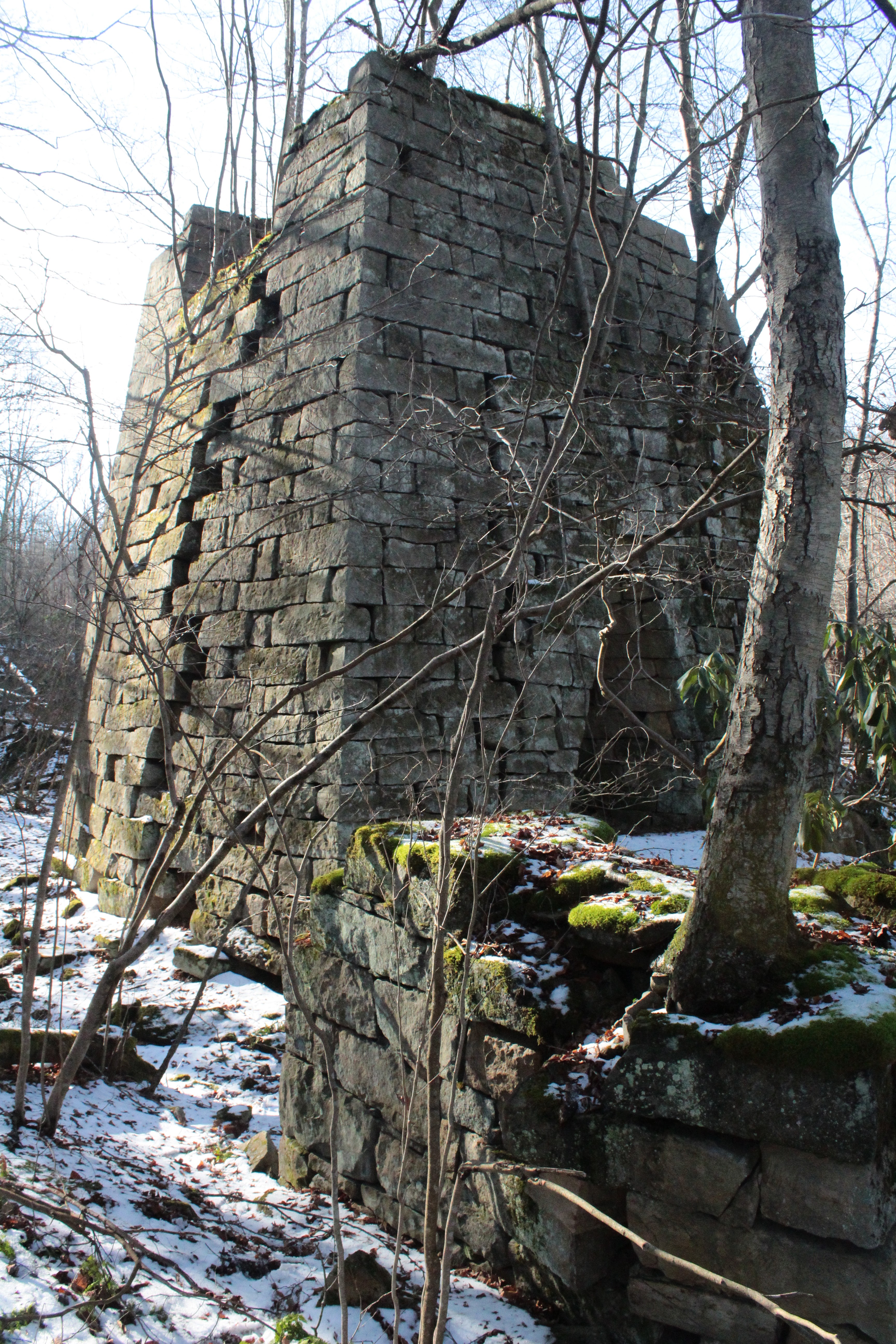
When we reached Cochran Mills we turned back. At one time there was a community here. The first mill in Burrell Township was built here in 1800. Before long more buildings joined it along with housing for the workers and a small settlement evolved.
One of the residents of the town was Elizabeth Jane Cochrane who later became well known as she wrote under the name of Nellie Bly. In 1887, she wrote about the injustices and evils of the Blackwell Island Lunatic Asylum by going into the asylum under cover as a patient. She also wrote about her journey around the world, challenging Jules Verne’s story, Around the World in Eighty Days. She accomplished the trip in 72 days.
The town was demolished in the 1930’s. Supposedly there are still foundation ruins of some of the buildings along Crooked Creek. We didn’t attempt to find them, preferring to stay in the car rather than hiking through the snow, perhaps we will do it another time.
Returning towards home, we stopped at the Pittsburgh Mills to meet our friends Frank and Kelle for lunch. After a filling meal we all went and found a couple more caches hidden around the mall area. Then we returned home.
As far as Friday the 13th’s go, this was a good one. Really though, I can’t remember any Friday the 13th that was bad. It is just a number; of course it’s one with a bad reputation. It’s sort of like how the full moon is supposed to cause more crimes. I figure that every day will be good if you look for all the good things in it. By concentrating on the better things in our days, they tend to stay productive and worthwhile. Always keep looking for the positive and hopefully our days will all turn out well.
Two of my favorite words are; triskaidekaphobia (meaning the fear of the number 13) and triskaidekaphilia (meaning the love of the number 13). In case you’re wondering when the next Friday the 13th will be, it will be next month and before the year is over there will be another one in November!
Chances are, they'll be good days!