Ending
A Month of Caches
January
2021
There was only a dusting of snow on the ground when I woke up. Walking out to
the car the coating on the sidewalk was less than a half inch. The car
windshield was frozen and I had to use the scraper before I could hit the road.
Being a Sunday, there weren’t many cars on the road which was just as well
since the snow had started falling again after I left home.
I
wasn’t going far, only a couple miles to a near-by park. It is located in the
steep valley a stream had carved over the course of centuries. Houses sit on the edges of the valley but
there are still lots of places in the park which appeared as wilderness. Well,
that might be stretching it a bit but there are some spots that appear isolated.
The place I was heading to this morning was one of those places.
It is a branch creek that fed into the main stream. A well worn path follows the
main stream through the center of the valley. The path is about a mile long.
Right near its center is a high waterfall. A couple small streams cut into the
valley feeding the main creek. The one I was heading for was steep and has only
one path, a path covered with a slim coating of snow and tilted on an angle
that nearly matched the slope of the hill! People don’t use this path very often,
in fact I imagine that the main users are the deer.
I
was searching for another geocache. I have been on a personal quest to
find at least one cache a day for the month of January. Today was the 31st;
if I find this cache I’ll meet my goal. Why you might ask? Well, let me attempt
to explain it to you.
For
close to a year we have been dealing with Coronavirus. This has upset the way
the world works. Cities, states and even countries have been shut down. At
times people have been told not to leave their houses unless it was absolutely
necessary. People have been asked to wear masks and to maintain social distancing.
Stores and restaurants have gone out of business because of these requirements.
Why am I even telling you this? You’ve lived through it also, you know!
I
would get my daily exercise by walking my dog but sadly I had to have him put
down because of degrading health. Afterwards, I tended to stay in the house
rather than going out for my daily walks. It’s a known fact that fresh air and
exercise is good for you, I needed to get off my butt and start walking again.
It
was the final day of the year and my friend and I went out to take some
pictures. It had snowed that morning and the conditions for good photos were
everywhere we looked! Snow outlining the branches of the trees, the snow in the
fields was unbroken and fresh, blankets of white covering the ground. While we
were out, we did a few geocaches. I
enjoyed the searches in the falling snow.
The
next day, the first of the new year, I went out and got a couple of the caches
we had missed the previous day. My first day of work was on Monday, the 4th.
Until then, I went out each day for a quick run to get a couple caches. If I
had to get gas, I’d see if there were any caches I could get along the way. My
weekly trip to the grocery store for supplies gave me another opportunity. OK,
I did a couple without any excuses. I was by myself and I didn’t see or talk
with anyone while I was doing it. I was being socially responsible!
It
was during the first week of work that I came up with the idea of doing a month
of caches. There are millions of them scattered around the world. There were
plenty along the route I’d take to go to work.
Before I’d leave I would check the computer and see if there were any I
hadn’t found on the way in. I’d make a list of a couple and attempt to find
them on my way.
Getting
back to the 31st, there were three cars in the lot when I pulled in.
This isn’t unusual since lots of people visit this park. I slung my camera around my
neck, put my gloves on and picked up my GPS and headed into the valley. I
brought my hiking staff also. I wondered if I’d see any others
while I was here.
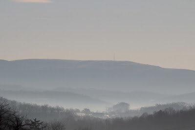
The
hillsides are steep, they aren’t the type of hills you’d roam around on. The
deer love them. Occasional streams
filter down from the neighborhoods above. Dramatic cliffs are situated where
the water has worn all the dirt away. Rocks and trees litter the ravines that these
streams have formed. In the winter with a coating of snow on them and ice
hanging off the cliffs, they look even more exciting and picturesque!
The
trail was slippery, footprints and paw prints had compressed the previous snows
into an icy coating. The mornings snow
hid the slippery surface, every step had the potential of a fall. Crossing the
first of the four bridges, I came to a sheet of ice. A spring situated beside
the trail drained across the trail and down to the stream below, leaving a
thick sheet of ice about six feet across. No big deal other than another
possible slip hazard.
In
my youth I wouldn’t have bothered with this. I’d walk across it never giving it
a thought. Now in my mid-60’s, my priorities have changed a bit. I tend to go a
bit slower, watch where my feet are going and watch the path ahead a bit more.
Being alone makes it even more important. I have my cell phone in case of an
emergency, but if it can be avoided, so much the better!
The
trail continued on without any difficulties. There is a steep portion that was
packed down but I avoided the ice on it by walking along the edges. There were
signs that someone had slipped here earlier in the morning, the snow had been
plowed into a pile from their slide. The
trail leveled off at the top and here, looking over to my right, I was able to
see the valley I’d be climbing into.
The stream is frozen and the hills are
steep
By
mountain climbing standards it was nothing. Anyone could climb to the top of
this crease in the hillside. It looks easier than it really is. In my youth we
played in this park and we had attempted going up this stream a few times. We
had never gotten very far. The brambles and steep sides kept our explorations
short. The stream works its way down from rocky cliffs, you can go up so far
and after that, a return trip is all that’s possible. I’d be going up one of
the hills rather than following the stream.
I
passed the valley and crossed my final bridge. I could see the path I’d be
taking outlined by the snow. Snow has that wonderful way of showing us things
we don’t normally notice. The paths of old abandoned roads, walls built decades
ago and now forgotten and the foundations of houses which no longer exist. I
love watching the hillsides as I drive after a snowfall. I never know what I
might see! My path showed up as a faint but distinct line climbing the hill in
front of me.
The
start was easy, the trail led up the hillside on a slant through a bunch of
dead leaves. After about thirty or forty feet the leaves disappeared and the
trail turned into frozen dirt. The snow on it gave me a bit of traction, I
wasn’t too worried. There were occasional saplings I could grab onto, going
up I really didn’t need them. Looking down into the valley below I realized how
high I was going. I figured if I slip, there are lots of trees along the way
down that will help stop me!
I
came up and rounded the edge of the hillside, below me I could see a waterfall going
over the cliffs. Long ice sickles hung from the edges. The hills on the other
side were just as steep, A couple small streams worked their way down to the
main stream. It looked beautiful covered in snow. The snow was still falling but
the exertion of the climb had heated me up so I unzipped my jacket and took off
my gloves. The climb became a bit easier as the trail leveled off a bit near
the top.
The
stream was off to my right, deep in a trough, hidden from sight. Looking at my
GPS I saw that I was within a couple hundred feet of my objective. I find that
often it is easier to just look in possible hiding places rather than follow
your GPS to ground zero. My GPS is over 15 years old and isn’t that accurate. I
find that my “geosence” works just as well if not better! I was hoping that the
cache wasn’t hidden down near the stream!
The
area was sloped towards the creek with LOTS of fallen trees. Stumps and trees
are often prime candidates for hiding caches.
So I started checking out the possibilities. My fourth guess showed me
the money! It was hidden in plain sight behind a large log. I was heading
towards its stump but as I approached I saw the camouflaged container. Looking
at my GPS, it showed me as being about 20 feet away from the hide.
If you look closely you can see the cache
under the log
I
opened the can and took out the log and signed it and then took a “travel bug”,
putting it in my pocket to drop off in another cache. Travel bugs have serial
numbers on them and by logging them on-line you can find out where they have
previously been. They are another part of the game of geocaching! I closed the container securely
and re-hid it, a little better than the way I found it and headed back up to
the path.
Easy going at the top
Coming
up was much easier than going back down! The first part was uneventful but
rounding the edge of the hill, the path dropped rather quickly. The slope of
the trail and the snow covering made it very precarious. I used the saplings
along the way to hold onto. My hiking staff didn’t help much, it slid on the
frozen ground rather than digging in. There were no leaves to walk on here. I
could also see the bottom of the valley and the stream, where I would end up if
I slipped. OH YEAH, the psychological
aspects of the climb!
Getting steep towards the end!
I
was happy when I finally got back to the main trail. At the bottom of the path
I met a woman and her dog. She was sitting on a three legged stool doing
meditation. Her dog patiently sat beside her as she exercised. We spoke for a
moment or two and then I left her to the quiet, peaceful snowy world of the
valley.
I
was stoked! I managed to make it up the hill and back without any major
screw-up! I had found the cache I was looking for and I had completed a month
of caches! At least one a day! I had actually found 77 during the month. Most
had been easy “guardrail caches” but a couple required two visits to find. A couple were found without using my GPS! My
favorites were ones that took me to places I had never been to before and the
ones that were harder to find, those were the fun ones!
I had found a couple caches in the remains
of old houses.
There was one I had found in another
valley, it had only been found three times since it had been hidden in 2017.
There had been no finds in two years and another geocacher found it the day
before I did! What are the odds?
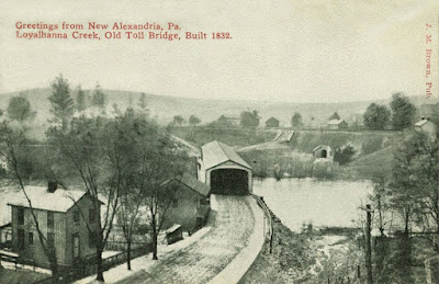
The game has taken me to some pretty cool
spots such as this old abandoned bridge along Montour Creek. We found a couple caches near-by.
Well, the month is now over and I’m going to put the game on hold for awhile… at least
until next weekend! Have a happy February!
 (Frank's shot)