Showing posts with label Pittsburgh. Show all posts

Monday, March 31, 2025

An Amtrak Journey

This may not be exactly what you were expecting... let me tell you a bit more.

    I’m not sure what it was exactly that brought the idea into my head. I was thinking about photography. This moved into catching a picture of a train coming through the city, with the buildings behind it glowing from the rising sun. “There had to be a spot where this could be caught!”

    I started by consulting my maps and a web site called “The Photographer’s Ephemeris”, a site that shows the direction and times of sunrise. I found out that Amtrak has a daily train to NYC, leaving the Pittsburgh station six days a week, leaving at 7:30! Looking at the maps, a couple spots presented themselves.

    During the upcoming days, I visited them. Some appeared better than others, there weren’t as many as I had hoped. My first attempt was from a parking lot beside the tracks.

    I had to wait for a good morning; wanting the sunrise reflecting on the buildings meant that I needed a day without rain or heavy clouds. This can be difficult in Pittsburgh. Finally a day arrived that met my criteria. I got there early, the parking lot was empty. I parked near a set of signal lights, hoping to catch the engine coming between them. The camera was set on a tripod, the scene was framed, all I needed now was the train.

    Just before it was due to leave the station a car pulled up, the window rolled down and a security guard asked me what I was doing. I explained and was told that I was on private property and would have to leave. I talked and maybe even begged a bit and was granted 5 more minutes. Just as this was given to me, the train came into view. I snapped my pictures, thanked the guard and tore down my set-up. I won’t be returning to this site again!

    The pictures were OK but I felt as if I could do better so… My next spot to attempt my picture from was a bit further away. I figured I could get a sharper image by adding a bit of distance from the train, making the speed of the train less noticeable, showing less blur.

    The sun was rising a bit earlier each day making the chances of sunshine on the buildings a little better but as I already said, the weather always plays a part in any outdoor photo shoot.

    The next site was on a bridge that spanned the railroad tracks, about 1000 feet further away from the last site. The day I chose was cold and the ground had a light layer of snow on it. Clouds were in the sky. I was glad I had brought gloves! The train came right on time but the city wasn’t lit up. My best picture from that day showed the snow blowing off of the top of the train; the city wasn’t in it.

    I returned a week later and tried again. While I got the city in the picture this time, once again the morning sunlight I had hoped for never developed.

    Looking at the pictures intrigued me. I decided to forget the city and go for another location. Out came the maps again. I found what looked like a good spot in-between Shadyside and Homewood. I took a ride to scout it out and it showed possibilities. A signal tower sat on either side of the tracks; maybe I could capture the train between the pair. The sun (if there was one) would be illuminating the front and side of the train.

    I returned with the camera to see what I could get. The sun was up, things were looking good. I decided to skip the signals since the lights wouldn’t be visible in the picture. The train came and a couple pictures were taken.

    These pictures were starting to become an obsession now! I decided to try again with my 4X5 camera so 3 days later I returned. I caught it between the signals this time, but the train was blurred, the shutter speed was too slow. Drat, always something!

    I started looking further out the line. Looking at the maps I noticed the tracks went underneath the George Westinghouse Bridge in East Pittsburgh. Oh it takes so little to grab my attention!

    My buddy Frank and I planned a trip out to where we thought we’d get a good view of both the bridge and the tracks. We had found a geocache a few hundred feet away a couple years ago. A bridge once crossed the tracks here and the pier provides a wonderful view of the valley. A section of the old brick road leading to the bridge is visible poking through the dirt and weeds. Stepping over a broken wooden roadblock takes you to a comfortable spot complete with a concrete shelf to put excess camera gear on and provide a windbreak.

    While we were setting up and then waiting, we watched a westbound freight pass by. Ten minutes later the Amtrak train came, about 20 minutes after it left the city. High hills are on either side and the light wasn’t the greatest…so we decided to come back another time.

    A week later, we were back again. The sunlight was just hitting the top of the bridge. We surveyed a few other sites in the area before we set up. Frank decided to go a little lower down the road while I stayed on the bridge pier. We got some nice shots including a few with the moon in them but we still weren’t satisfied. Was I pulling Frank into my obsession?

    We returned one last time. (at this writing) It was eleven days later on a Saturday morning. There were occasional drizzles as we drove back to East Pittsburgh. We brought Kelle and Ann Marie with us this time, for company, perhaps good luck and to share the excitement of the hunt.

    This time we set up underneath the smaller bridge in front of the Westinghouse Bridge. While the on and off rain never came down hard, the bridge provided a cover for us.  It also gave us a different view of the train and the bridges.

    I brought my 4X5 camera along and I set up a bit closer to the tracks than Frank. The women hung out beside the car. We heard lots of train whistles while we waited but none of them were from the train we were waiting for. Then we heard it, there was a definite difference in its sound! The headlight first appeared between the branches of the trees and then there it was, speeding towards us. I took a few shots with the digital camera and then depressed the shutter release on the bigger camera. A couple more digital shots of it as it raced away from us and then I started tearing things down. All that preparation for only 10 or 20 seconds of excitement, was it worth it? As far as I was concerned, it was!

    We repacked the car and headed for a place to get some breakfast to celebrate a successful trip. Even if the pictures don’t come out as we planned for them, we were still happy!

    Thinking about the various shots I’ve taken, I figure this will probably be the last time we come out to this spot. I can let this series go now. I developed the 4X5 negative, it came out OK, it’s the photo at the top of this story.

    I don’t think I’ll be chasing this train any further. It was nice knowing when it was going to pass as compared to just standing trackside and hoping a train goes by. Should it pass me again, I’ll take another couple pictures of it. I’ve been taking shots of this train long before this year.  

A past shot of the morning Amtrak train coming into the Horseshoe Curve

The search always continues, whether or not I get anything isn’t important, it’s all about the hunt


Tuesday, October 31, 2023

Pittsburgh’s Early Start in the Iron Industry

 Pennsylvania and especially Pittsburgh has been known as a major part of the iron and steel industry. When the steel mills lining the rivers gave the town the reputation of “The Smokey City”, the trade was decades if not a century old.

    Alleghany County had two early iron furnaces. The areas around both sites have been developed and no sign of these early manufacturing plants remain.

    The first one, called The Shadyside Furnace was built in 1792, two hundred and thirty-one years ago. It only operated for a year due to the lack of near-by iron ore.

  Stefan Lorant’s book, Pittsburgh, The Story of an American City, has a painting of the furnace done by Walter A. Gasowski. The area where it was, once forestland, is now filled with buildings and roads. Shadyside Furnace was located near Shadyside, a place not really associated with dirt, smoke and noise. The furnace was built somewhere near the end of Amberson Avenue, where the busway and railroad tracks are now. The Pennsylvania Railroad effectively erased any sign of the furnace when they put their tracks in around 1860.

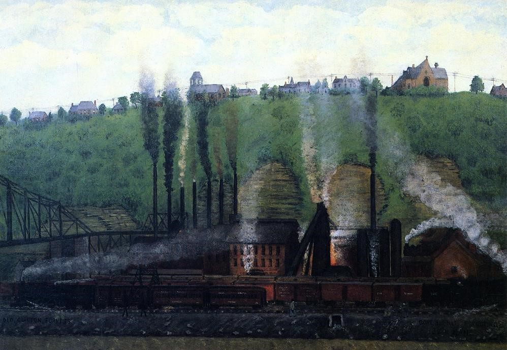
    The second furnace was called The Clinton Furnace. Built in 1859, it was fueled with coke instead of charcoal. This practice provides a much higher heat and a much more efficient process. The furnace continued operating until 1927!

The location of this furnace is shown in a painting by Pittsburgh painter, John Kane, done in 1920. Looking at the painting you can see the St. Mary of the Mount Church (1897) on top of Mount Washington above the furnace. You can also see the Wabash Railroad Tunnel and bridge. The bridge has been demolished but the tunnel remains, now used by cars. The furnace sat close to where Carson Street is now. The edge of one of the RR bridge piers can be seen in the left side of the picture below.


    In 1905, things had modernized a lot at the Clinton Furnace, Pittsburgh was well on its way into the steel legend it would become.

    These two furnaces weren’t the first ones in the state, just the first in Alleghany County and as we all know, the iron and steel industry BOOMED here in The Steel City.


Thursday, March 30, 2023

Gotta Map?

During some of my recent bookstore visits, I picked up a couple books worth mentioning. Both were purchased at City Books on Pittsburgh’s North Side and both of the books have to do with maps.

    The first is a nearly new book (2018) called The Writer’s Map. It contains a group of articles by twenty-four different authors. These essays or chapters are about how maps are often included in books and can also be influential in the first thoughts of a new book or story.

    The illustrations in this larger format book are very nicely copied, having maps of both real and imaginary places. All of them were made to help us find our way, whether through the real world or the book we are reading.

    I always enjoy having a map included on the inside cover of a book, (This book has one!) I refer to them frequently and am disappointed when they aren’t a good representation of the novel. These maps make the location of a story that much more real to me. It helps me to envision the place!

    The second book is an old Collier’s World Atlas and Gazetteer. Printed in 1935, it has the ability to take me back into the past.

    Back to when Alaska and Hawaii weren’t states yet, back to a time when the city of Pittsburgh was covered with railroads. I find it fun to browse through the maps and see what has changed over the past eighty-eight years. There are countries, and neighborhoods in this atlas which no longer exist and lots of places which have been absorbed by others. The statistics have changed a bit also. 

    There are a couple older atlases and maps in my collection which show Pittsburgh being spelled without the "h" at its end, (pre-1911) and where West Virginia hasn’t yet divided from Virginia because of different thoughts dealing with slavery. (Pre-1863) Looking at old maps can be another form of time travel.

    I find maps absolutely fascinating, whether they are the old crinkly maps, printed on tissue thin paper in the Beadeker Travel Guides, old folded gas station maps or star maps printed on thick paper in the Uranometria volumes. I have a couple atlases of the human body, filled with color plates showing the bones and what muscles are used to power them along with maps of the veins and arteries that fuel them.  Pictures of the human body, but they are maps never the less. In novels, my opinion of a book rises if it contains a map, or even better, a few maps! Maps such as; the Treasure Island map on the inside covers of the book, Swiss Family Robinson’s map, the map of Steinbeck’s Travels with Charley or the jungle maps of The Lost City of Z. They all guide us through the book. What a wonderful accompaniment!

    While reading The Writer’s Map, one of the chapters was written by Reif Larson who wrote The Selected Works of T.S. Spivet. Some of the maps in this book are included and after reading that chapter, I went to the bookshelf and pulled my copy of the book out and started re-reading it. As of right now, I’m about 60 pages into it. What a great book!  (It is about a young, (very young!) cartographer who is invited to make a speech at the Smithsonian Museum. They have no idea how old he is. He sets off on his own, going from Montana to Washington DC, mapping his journey in his journals. I’ve re-read it a few times and enjoyed it every time.)

    The fact that I started re-reading this book once again is an example of how I believe that all books are connected in some way. Books I am reading often have a similar plot, the same location or the same subject matter as the one I just completed. This doesn’t happen all the time but it occurs enough that I look forward to seeing what similarities the book I’m reading might have with those of the past. This example also shows how one book can lead me to another. In a way…it was a map to the book that was sitting on my shelf.

    A quote from another book I just read, The Lost Continent by Bill Bryson fits right in here. Writing about his father; “there was almost nothing he would’ve liked better than to cover the dining room table with maps and consider at length, possible routings”

Maps, where would we be without them?   I know I’d be lost!


Wednesday, January 18, 2023

Visiting The Past

Let's climb into our time machine and travel back into the Pittsburgh that existed in 1986.  These pictures, taken 37 years ago, back in the last century, show some things that have changed in the ensuing years. So often the things we take for granted are just wrinkles in the fabric of time.

    The first is on the 6th Street Bridge, which is now called the Roberto Clemente Bridge. Do you remember when the city had life preservers mounted on the bridge? I didn’t. If you look at the background buildings, you will see a billboard for Horne’s Department Store. Both the store and the billboard are now gone.

    Who doesn’t remember Gimbel’s? There were some scattered around the Three Rivers area but the main one, was in downtown Pittsburgh. I can remember going to see Santa and visiting their Toyland when I was a kid. I also seem to remember a noisy, narrow wooden escalator going down into the basement. (?)

    The stores were all over the country, originating in Indiana in 1842. The Pittsburgh store opened in 1914 and lasted until the company went out of business in 1986-87. The building later housed the first Barnes and Noble Bookstore in the city and was added to the list of historical landmarks in 1997.

    All the buildings in this block, Liberty and William Penn Place, are no longer standing. The White Tower, Jack’s Sport Haven, The Nixon Hotel, The Liberty Tavern, Mary Ryan’s and the Palace Burlesque Theatre, no doubt all assets to the community, have disappeared.  The August Wilson African American Culture Center resides here now.

    Back in “those days”, Pittsburgh had quite a smorgasbord of adult venues on Liberty Avenue. The vast majority, if not all of them, have disappeared.

    The Art Cinema has been cleaned up and now shows art films in Pittsburgh’s Cultural District. (Once called Pittsburgh's red-light district) In 1995 the cinema was renamed The Harris Theater.

    The circus used to come to town yearly, traveling from town to town on the railroads. At one time, unloading their cargo in the strip district and parading the animals up to the Civic Arena for the show. In 1986, they had moved to the rails behind the Pennsylvania Station to park their trains while the show was in the city.

    One morning I was driving through the city before work, looking for a picture or two when one showed up right in front of me. I pulled up at a stop light and there it was, right in the back of a truck!

     The circuses have shut down, their railroad cars sent to museums and the Civic Arena has been torn down so they, as Joni Mitchell would say, could “put up a parking lot”. Looking closely at the picture, you’ll see it was taken in front of a Bell Telephone Company Building, there’s another thing that’s gone! And then, there is that Pittsburgh Press newspaper dispenser...

    We will end with one last picture from the North Side before we return to the present day. The building is still there but the business is gone. Located on Chestnut Street; the sign didn’t last very long, maybe only a month or two. Why…I really can’t imagine.

    So, whenever you’re out and about, keep your camera (or cell phone) near-by. You never know when the things you’re seeing… might disappear!


Thursday, December 8, 2022

Astronomical Pittsburgh - 1996

 Sorting through slides taken over the years, I came across a small box with the title “Ast Pgh”.  Opening it, I found a batch of slides I had taken in the mid 90’s. They were of places with astronomical names. Many of these places no longer exist. How many do you remember?

The streets are still there, so let’s start out with them.

Brashear Street, named after John Brashear, is in Point Breeze.

Telescope Street in the city’s Southside, not far from where John and Phoebe Brashear lived.

Jupiter Drive in Hampton Township.

Moving into the planets, I started by visiting the Venus Diner in Hampton Township. It has since been moved to another location, possibly in another state.

Then I visited the town of Mars! I always thought this historic sign was interesting since it states the town was named after the star Mars, not the planet…

and what would a visit to Mars be without seeing the UFO?

The planetary visits stopped with Pluto’s, in the Strip District. Pluto is no longer a planet and Pluto’s is no longer a nightclub.

Moving into the stars, there was Starlite Classics located in Wilkinsburg,

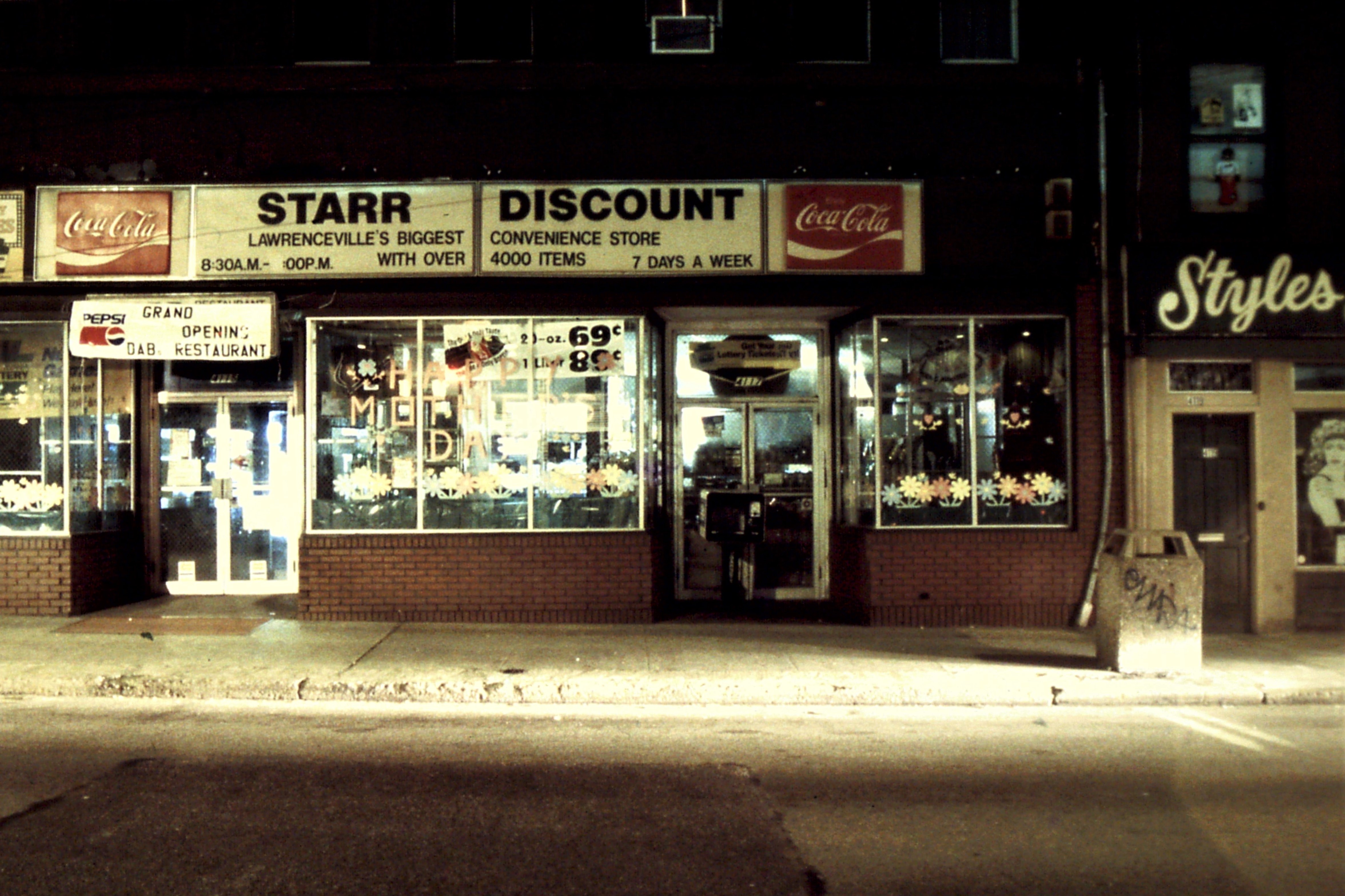
and Star Discounts on the main street in Lawrenceville.

Star Tile And Marble was in Aspinwall.

The Starlite Lounge was in Blawnox,

and less than a block away is Moondog’s.

The Comet News was in Braddock, and finally,

here’s a picture that was taken on that same roll of slides,

a comet flying over Wagman Observatory…1996, it was a fun year!


Friday, October 14, 2022

Into the Burgh

 The moon was sitting high in the predawn sky with the red planet Mars off to its upper left. I had come outside to check on the temperature, to figure out how warmly I should dress for the day’s adventure. As I was gazing into the sky, Frank pulled up and within 10 minutes we were on our way. The sun broke over the horizon as we drove down into the city.

    We were on another hunt for both caches and photos. We had a small list of caches situated around downtown Pittsburgh and we had our cameras with us, as always, in case anything photogenic jumped out at us!

    We parked on the top floor of a parking garage and spent a few minutes “hanging” over the edges taking shots of the traffic and people below. Then we headed towards the hill.

(Frank's shot)

    We headed east, going through Strawberry Way, towards the USX Tower and the sun. Our first stop was in the town’s newest green space, Frank Pace Park. Named after a Hill District community activist, the park spans Interstate 579, a 2.7 mile highway cutting through the city. When it was built, hundreds of homes were destroyed in the process, even more were removed when the Civic Arena was built. This park spans the canyon that the highway created between the city and the Hill District.

    There were two caches located in the park and we quickly nailed them. Easy-peasey! From there we headed over towards Flag Plaza, only to find our way blocked by construction. Our plans weren’t written in stone, so we dropped back down into the city again. Coffee and donuts were callin’.

    We talked with some religious folks standing on the corner looking for converts. We discussed the weather and photography and went on our way, nice people! We met some others later in the day and had the same experience, no hard sell, just a nice conversation. Sitting by a fountain, we ate our sweets and sipped our caffeine and then returned to our hunt.

    We stopped in the Union Trust Building and took a few shots in their lobby. What a spectacular place! From there we worked our way down past the Kaufman’s Clock, (or is it now the Target Clock?) and towards Market Square.

    We did a cache near the skinniest building in the city. Located at the corner of Wood and Forbes, the Hendel Building is only 5’2” wide. The building is considered one of the skinniest buildings in the world! It has housed a lunch counter amongst other things. It currently is under construction since a new owner purchased it.

    We visited Market Square and people watched for a bit, visited a camera store and some alleyways before heading back to the car. (Love those alleys!) We drove around a small detour and snagged the cache at Flag Plaza and then headed home by way of Oakland. Two more caches waited for us in the University section of town.

    We visited the statue of The Pitt Panther outside of the Pitt Student Union and then The Westinghouse Memorial in Frick Park before returning home.

    We found 6 out of the 7 caches we looked for, 85% approximately, not bad! We also got some nice shots in the process. We were both surprised at how few people we saw in the city. We remembered when people crowded the sidewalks, especially at quitting time, lining up 4 or 5 deep waiting for their buses. The times have definitely changed! It is still a beautiful city; it is a shame that more people don’t visit it or work in it anymore…


On a Small Road near North Park

On the edge of North Park sits a road that cars can’t use. There are stories that have been shared about this road over the years. Often, th...