Tuesday, December 12, 2023

A Ghost Town in Southeastern Butler

A ghost town is a place that once was an active community but has since been abandoned by all or nearly all of its residents. Buildings, ruins and sometimes only roads remain. Ghost towns can be found on every continent.

    Friday morning I met two other photographer/explorers and we headed north into Butler County. Getting up early, I was able to see the planet Venus and the moon high in the sky as I packed my car. It was looking good for the day ahead!

    Franko, Bob and I got off rt.28 near Freeport and headed east to Winfield Road. We passed through farmland and eventually dropped off of the top of the hills and entered into the valley. A huge cement plant sits at the bottom of the hill, right beside our destination, West Winfield.

    Making a turn, we entered what used to be the main street of the community. Today, there is nothing there. Houses lined both sides of the road for about a ½ mile or so. There was a plant which processed limestone from the mines across the stream. A railroad ran into the town and further down the road, a brick plant used to operate. Earlier in the town’s history, an iron furnace produced pig iron which was ferried by mules down to Freeport along what would later become the rail line.

    For a while the town was known as Winfield Furnace before becoming West Winfield. Interestingly, West Winfield sits on the eastern edge of Winfield Township. (There is another Winfield in Pennsylvania, about 50-60 miles north of Harrisburg. It had an iron furnace in it also. Could this be why it is called “West” Winfield?) The town was a “company town”. The houses were for the miners and workers who processed the limestone dug out of the hills around it.

    The town was rather big, it had stores, a school, a Roman Catholic Church, (St. Mary’s) and a Protestant Church, a Post Office and railroad station and of course, lots of jobs. One of the stores was run by the limestone company and you could get your pay there, and have your purchases taken right out of it. Houses and buildings lined the road.

    The town was divided by the railroad tracks, most of the people living above the tracks were of European ancestry while the newer immigrants (?) lived below the tracks. (On the wrong side of the tracks?) Why the town disappeared isn’t known to me, maybe because the jobs were no longer there. The railroad tracks were removed in the early 80’s and the houses were torn down around the same time, give or take a decade or two.

    We started out on the far side of town. We looked along the old RR path looking for anything exciting. We came across an old coupler near where we think an incline might have been. We found a slew of bricks, none of which were interesting to the brick-collector of the bunch.

    In our group, we had one guy looking for old and interesting bricks, another who was photographing the streams, waterfalls and trees and me, who was mostly excited about re-visiting the Winfield Furnace. An odd group but we worked well together!

    We gradually worked our way back into the main section of what used to be the town. A small level spot in the road marks where the tracks used to cross it. Following this track we passed where a train station used to stand. There is nothing to suggest that any buildings ever stood there. It is a short walk to where the stack stands. High tree-like shrubs hide it from view. Piles of asphalt and a few pieces of metal machinery sit in what used to be the rail yard. 

If you are looking for the furnace you’d find it, if you were just walking through, you might pass it without ever realizing it.


    The furnace was built in 1847 and produced iron for 17 years, going out of blast in 1864. The stack is still standing tall but parts of it have collapsed into the center. Some of the stones have cracked and there are plants growing on it but all-in-all, it looks pretty good! There are various things painted on the stones but none are recent and they are slowly eroding away, like the furnace. I’ve said it before, it is sad that we as a people choose to degrade things to enable our being remembered. I’ve never understood the urge to put graffiti on old structures or buildings. (This could be another blog completely!)

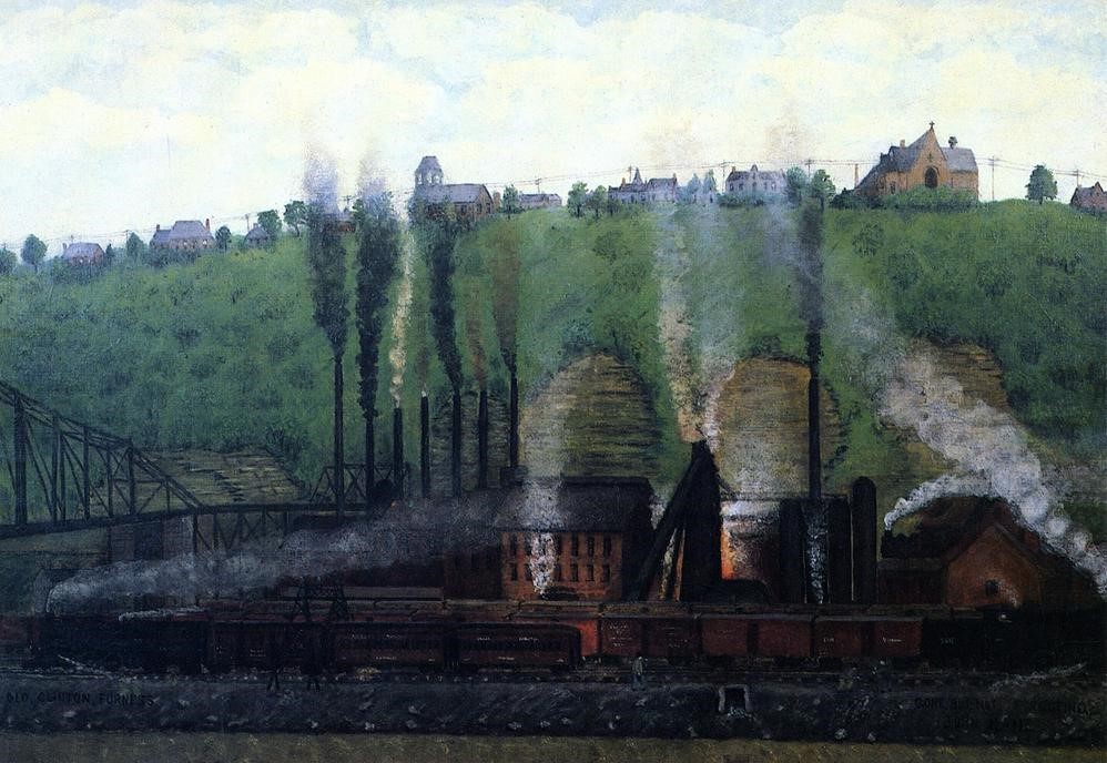
    One of the men I was with told me that there was a pit near the furnace in which a railroad turntable had sat. In the picture above which was taken after a flood in 1904, both the furnace and the turntable can be seen. It supposedly spanned 60’. The turntable can also be seen in the first picture in this blog, in the bottom left, right above the word “birdseye”.

    I didn’t remember ever seeing it before and was excited when he pointed out where it was. I needed to work my way through some rather thick brush to get to it and I couldn’t really see it until I was actually inside it. It was filled with dirt and debris on one side and there were lots of things growing in it, obscuring the view. 

    Once I saw the wall, about 2-3 feet high, I could see the radius, the curve of it. Once I had seen that, I could picture it. I had walked over some stones from the wall on my way in and hadn't realized it. I would love to see what it would look like cleared out. Is there a center still in it? I’ll have to bring a small shovel with me on my next visit! 

    I have been to this site at least 12 times now. I took the picture above sometime in the late 70’s, you can see that the railroad was still there. I believe it was my first time to see the furnace. I think I first found out about it while reading A Guide to Historic Western Pennsylvania, a book that is still in my collection and used often.

    We all enjoyed the day and returned with a lot of pictures. Along with pictures I came home with some questions…why did the town disappear? Did the people just drift away as jobs became scarce? Does the cement/limestone company still own the area? Why did they bulldoze all the houses? Were they vandalized or was the company worried about fire or lawsuits? Hardly anything is left. Nature is taking it all back. Luckily, there are some records of the town along with a few pictures.

    West Winfield, stop by and visit it, a bit of Butler County history that is slowly fading away…


Friday, December 1, 2023

A Visit to Mount Vernon


With tints of orange and pink decorating the eastern sky I loaded my car and went to pick up Jim. We stopped for Ann Marie and then headed south. It was a beautiful morning and we were hoping for clear skies for our trip.

    We were off to visit Mount Vernon, not the one in Virginia, home to our first president but the one in Bullskin Township, just a little closer. There is a connection to the president though!  Not far from the city of Mount Pleasant in Westmoreland County, just across the Fayette County line, lies what used to be a small community called Mount Vernon.

    With our usual breakfast snacks and cups of coffee we were ready to traverse the countryside. We followed rt.66 south, avoiding the “new” toll section, eventually driving through Greensburg, the county seat of Westmoreland County.

    As you come into the main section of this town, you crest a hill and the dome of the courthouse can be seen ahead. You have to pay attention as you drive through the city, the arrows on the roads change lanes in each block. It is a beautiful town with lots of impressive old buildings. Ann Marie and I will be returning one of these days to do a “walk about”.

    Passing through the town we eventually came to the edge of New Stanton, where rt. 66 intersects with rt.119 and the turnpike. We merged onto 119 and soon were coming into the Mount Pleasant area.

    Driving towards the east the sunshine on the windshield made us turn down the heater. Outside, the temperatures were close to freezing. We drove across hilltops with views of farms stretching out to the hills in the distance. A few animals were in the fields making the scenery even more spectacular, worthy of a calendar! Best thing of all was that there were no other cars on the narrow roads, we could take our time and enjoy the views.

    It didn’t take long to reach Woodsdale and the Mount Vernon Park. The first thing we did was to go outside, braving the cold…to get a couple geocaches. They were quick and easy finds and once found, we could go to what it was that brought us here, the Mount Vernon Iron Furnace.

    Even though this is an extremely old furnace, built in 1798, nearly 229 years ago, it sure doesn’t look like it! It has been re-built at least two times. It’s first re-do was in 1801 after an explosion destroyed part of the furnace, along with killing some of the workers in the process. More recently it was redone in 2006 by the Bullskin Township Historical Society, a process that has taken well over 10 years.

    The furnace worked for 32 years, finally being blown out in 1830. A small town named Mount Vernon surrounded the furnace, containing a schoolhouse, stores and houses for the workers. They are all gone now, all that remains of this community is the stack.

    The man who built it and owned it, Isaac Meason, named it in honor of his friend, George Washington. Meason owned four other furnaces in the area, his house still stands a bit further south in Dunbar Township.


    Bullskin Township started cleaning up the furnace and the area around it in 2006, the work continued on through 2016. They have succeeded in making a wonderful exhibit showing what iron furnaces made and how they did it. The destructive trees and plants have been removed from the stones which will help it survive much longer. The area has been cleaned up, a local man made a water wheel to add to the site, a casting shed has been added along with signage that help explain the process of making iron.

    It was definitely worth the time to drive down here to see this! Since we were so near, we decided to visit another Pennsylvania historic site. Just about 8 miles away sits the town of Kecksburg.

    On December 9th, 1965, reports were made of a mysterious object flashing across the sky. It was seen from 6 states and Canada. In Kecksburg, people reported seeing blue smoke, feeling vibrations and hearing a loud “thump”. Apparently, something had landed in the woods near-by. State police and the Army sealed the area, keeping people away. Some residents said they saw an Army flatbed truck leaving the area with something covered with tarpaulins. Officials said that nothing was found.

    All sorts of tales arose afterwards. Some said it was a Soviet satellite, others said it was an American spy satellite while others think it came from another planet. Years later, NASA supposedly said that pieces picked up at the scene were from a spacecraft originating in Soviet Russia. When asked for documents, they said that the paperwork was surprisingly, missing! 

Witnesses said they saw weird hieroglyphic writing on it and that it looked like an acorn.

    What happened that night is still unknown and is up to speculation. It is up to the individuals reading and hearing the multitude of stories and reports about the incident to decide for themselves. A yearly UFO festival is held in the town. There is a museum and a gift shop across the street from the replica the town mounted on a hillside. Sadly, they weren’t open when we visited.

    All I can say is that here in Kecksburg, less than ten miles away from the now non-existent town of Mount Vernon, history was somehow made back in 1965. With this last bit of history in our minds we turned the car around and returned back to Pittsburgh, happy to have soaked up a little more of what Pennsylvania has to offer.


Wednesday, November 22, 2023

A Rainy Day Stop

 With the rain coming down steadily, Ann Marie and I took a “small” detour on our way to Beaver Falls to visit relatives. What was it that took us 20 or 30 miles out of our way? It was just a small pile of stones in the north-east corner of Beaver County, not far from Zelienople.


    These stones had been placed there about 210 years ago. While it doesn’t look like much now, this small pile of rocks was once one of only three iron furnaces located in Beaver County. The Bassenheim Furnace is the only one still in existence; the other two disappeared long ago.

    One of the other furnaces, the Homewood Furnace, was located near Elwood City. Back in the 1960’s the furnace site was under the town dump. The furnace, erected in 1858, had been situated along the Beaver Canal. It operated only about ten years.

    The other Beaver County furnace was called The Beaver Falls Furnace, or The Brighton Furnace. This had been built in 1808, the earliest of the three. Operating for about 18 years, it was located near the “middle falls” where Walnut Run enters the Beaver River.

    The pile of stones we visited, The Bassenheim Furnace was built in 1813 by Dr. Detmar Basse, the founder of Zelienople. It produced iron for about 10 years before it shut down. The quality of the iron it produced was good. The near-by forests provided charcoal to fuel it and limestone was procured from a cliff about a mile to the north. The ore came from local sources also.

    Situated along the side of Doe Run or Connoquenessing Creek, a water wheel powered bellows to help intensify the heat of the furnace. A dam was situated across the stream and the water was directed across the wheel to turn it. One of the reasons it closed down was the high cost of transporting the iron after it was made.

    While it was in operation, a small community surrounded it. Housing for workers, sheds to protect the furnace and the tools needed to run it, along with various out buildings such as stables. There were roads leading to and from it, including what I am guessing might have been a road to the top of the furnace where it could be loaded, the path we walked in on.


     The stones are what appear to be field stones, very few of them look as if they have been shaped. There are only a few that show the straightness of the outside wall. The backside has collapsed and is hardly recognizable as a furnace. There are no signs of any other structures in this area.


    A historic marker sits alongside the road, but it isn’t readable to those speeding past in their cars. A larger sign has been erected by the local Kiwanis Club to help bring attention to the site. Most people rushing past this intersection have no idea of the Beaver County history that occurred a couple hundred feet away.

    The rain continued to fall and our jackets and shoes were getting soaked, so we packed up and returned to the heat of the car, with another iron furnace under our belts. Also, there were still a couple geocaches to find before we got to Beaver Falls!

Tuesday, October 31, 2023

Pittsburgh’s Early Start in the Iron Industry

 Pennsylvania and especially Pittsburgh has been known as a major part of the iron and steel industry. When the steel mills lining the rivers gave the town the reputation of “The Smokey City”, the trade was decades if not a century old.

    Alleghany County had two early iron furnaces. The areas around both sites have been developed and no sign of these early manufacturing plants remain.

    The first one, called The Shadyside Furnace was built in 1792, two hundred and thirty-one years ago. It only operated for a year due to the lack of near-by iron ore.

  Stefan Lorant’s book, Pittsburgh, The Story of an American City, has a painting of the furnace done by Walter A. Gasowski. The area where it was, once forestland, is now filled with buildings and roads. Shadyside Furnace was located near Shadyside, a place not really associated with dirt, smoke and noise. The furnace was built somewhere near the end of Amberson Avenue, where the busway and railroad tracks are now. The Pennsylvania Railroad effectively erased any sign of the furnace when they put their tracks in around 1860.

    The second furnace was called The Clinton Furnace. Built in 1859, it was fueled with coke instead of charcoal. This practice provides a much higher heat and a much more efficient process. The furnace continued operating until 1927!

The location of this furnace is shown in a painting by Pittsburgh painter, John Kane, done in 1920. Looking at the painting you can see the St. Mary of the Mount Church (1897) on top of Mount Washington above the furnace. You can also see the Wabash Railroad Tunnel and bridge. The bridge has been demolished but the tunnel remains, now used by cars. The furnace sat close to where Carson Street is now. The edge of one of the RR bridge piers can be seen in the left side of the picture below.


    In 1905, things had modernized a lot at the Clinton Furnace, Pittsburgh was well on its way into the steel legend it would become.

    These two furnaces weren’t the first ones in the state, just the first in Alleghany County and as we all know, the iron and steel industry BOOMED here in The Steel City.


Wednesday, October 25, 2023

A Spur of the Moment Vacation

 It was Wednesday night and I was debating about taking a ride to Hollidaysburg the next day. There was a talk being held at the Blair County Genealogical Society (BCGS) about, of all things, iron furnaces! The more I thought about it, the more I wanted to go. The only problem was that Hollidaysburg, the county seat of Blair County, was about two hours away, which would mean a long drive in the dark to get home. I don’t mind leaving on a trip in the dark, but returning home is another thing completely.

    I talked with Ann Marie and we decided to get a room for the night and turn the trip into a small vacation. A few minutes later and there was a room waiting for us for the next day.

    Thursday morning had me loading the car as the sun neared the horizon. Everything was orange, the sky, the clouds and the trees. I debated digging the camera out of its bag but instead just stood for a minute or two and enjoyed the view, then got in the car and started my trip.

    I arrived early at Ann Marie’s but she was ready and waiting. As is always the case, our first stop was for coffee followed by some breakfast. After some eggs, bacon and toast and a very unsuccessful attempt at solving the crossword puzzle on the placemat, we continued with the journey.

    The trees looked great in the early morning light; fall was definitely well on its way. Bits of fog still clung in the valleys and the treetops making the views spectacular no matter which way we turned. A couple stops were made for geocaches and possible train sightings but even with these, we were in Hollidaysburg by ten. We stopped first at the local library. They were holding their annual book sale and we always try to support the libraries we visit. We both came away with a couple books.

    After that, we drove out of town to the cliffs overlooking the city. Known as Chimney Rocks, they provide a nice view of the town and the surrounding countryside. A small, steep hike is required to get to the top of the ledges. We found another geocache while we were there but even more importantly, we visited an iron furnace which was built into the hillside below the cliffs.


    I couldn’t find much about this furnace other than a couple brief mentions of it on-line. I did find some old currency that was being sold on E-Bay which references it and I also found a mention of it in a book dated 1859. This book says that the furnace was near the train station, the furnace we visited was about a mile away and up the hillside. This furnace is interesting in the fact that it has a concave front, only one opening and is nowhere near any water. Is it the same furnace? I don’t know!

    Later that evening, at the BCGS we met Byron Smail who was giving the talk. His book is called The Iron Furnaces of the Cove! Williamsburg, Martinsburg, Roaring Springs, McKee”. The book covers the various furnaces that had been built in the “Cove”.

    I had never heard of the Cove before. I always thought of a cove as a small harbor or indentation in a body of water. Looking the word up in the dictionary I found out that it also means; “A deep recess or small valley in the side of a mountain or a level area sheltered by hills or mountains”.

    It was a nearly standing room only crowd. What a nice group of people. Byron gave an excellent talk, showing pictures of the furnaces and places he was talking about. He explained how these furnaces worked and the differences between charcoal and coke fueled furnaces. He had some examples of slag and iron “rock” to show also. The man knows what he was talking about! I picked up a few books from the society’s bookshop while we were there. Ann Marie and I were glad we came. We were also glad that we didn’t have to drive back in the dark!

    We woke up to rain but that didn’t stop me from finding another geocache about a ¼ mile from the motel. I then got coffee for the two of us and returned back to the room where I promptly spilled all of AMB’s coffee on the table. My mutterings and curses were probably what woke her up!


    We drove into Altoona passing the Allegheny Iron Furnace, (built in 1836) about a mile and a half from where we stayed. Then we cruised some of the alleys and back roads of Altoona looking for trains and the Boyer Candy Company. They make Clark Bars and Mallow Cups there. I was hoping to get a tour but that was no longer being offered. We made do by visiting the retail store and stocking up on some candy.

    Leaving Altoona, we stopped at the small town of Gallitzin. The public library sits right beside the portals of the tunnels leading from The Horseshoe Curve. No trains passed by while we were there. In the library I saw a book set up on a display stand, written by a friend and fellow astronomer Ken Kobis. Cool!

    The next stop was in Johnstown where we stopped at another library. The Cambria County Library has a bookstore in it and while AMB browsed the shelves, I went up to the third floor to visit the Pennsylvania Room. I looked at a couple of old books about iron furnaces while I was there. On our way out of town we stopped at a small restaurant and had an excellent chicken meal for lunch. We are often surprised at the good experiences we have when we “try” a place that we just happened upon.

    We were back at our homes by mid-afternoon, both of us pleased at how well the trip went. We got some great fall leaf viewing, learnt some new facts about iron furnaces along with seeing a couple, visited a few libraries, picked up some more books, got a few more geocaches and had a whole lot of fun doing it. Not bad for a spur of the moment decision.


Saturday, October 7, 2023

Going to the Maps


I had just finished reading “The Cartographers” by Peng Shepard and was thinking about it. It was about maps and how they have the potential for making places real. While the book was about using a map as a key to entering a place no one else could go to unless they held the map, I’ve always thought that maps made things real to us. By showing us the way to go, we can experience places that we’ve only heard about.

    Every time I go on a trip, or even think about the possibility of going on one, I go to my maps. Atlas’s, gazetteers, simple folded gas station maps, (remember those?) and even the simple to use, internet maps, I use them all. Looking at them I can decide which routes to take, I can determine whether it will be a quick speedy journey or a scenic one. I can find places to stop and places where things can be found and uncovered. Maps are as important to me as my books are!

    I recently saw a picture of an old furnace that someone had posted. My curiosity piqued, I pulled out my reference materials.

    The first step was to check a book I have about iron furnaces. Published during the second half of the last century, A Guide to the Old Stone Blast Furnaces in Western Pennsylvania, written by Myron Sharp and William Thomas, has been invaluable to me, helping me find numerous old furnaces. Some were mere piles of rock, a few were empty fields or parking lots but there have also been a lot of exciting structures found. Some are hidden deep in the woods, inaccessible to anyone except those who don’t mind a bit of discomfort in their exploring. Some are sitting in plain sight beside the road. This book has taken me to numerous furnaces which while being over 100 years old, still show the mastery of the men who put them together!

    With a little more information about the furnace, I turned next to my Pennsylvania Gazetteer and tracked down the roads mentioned in the book. I also checked a couple other books I have to see if there was any mention of the furnace in them. I added more notes to my list and then I moved into the present century and the computer.

    I visited a favorite search site called Waymarking.com. They have a category called Iron Furnace Ruins which consists of seven pages of furnaces located around the world. I quickly found the furnace I was thinking about going to and clicked on it. I was presented a couple pictures and a GPS location! I copied them all. I put a mark on a map indicating where it was located.

    With Google Maps, I had a good idea of what the countryside looked like, the satellite view showed me near-by road marks, places which would help keep me on track.  On-line topographic maps helped me see what kind of hills and valleys I might encounter.

    I also searched the maps on Geocaching.com to see if there were any hides in the area. A new cache had been listed at a site that I had visited before, near another iron furnace. Located with-in 10 miles of the other, as the crow flies, I added it to the list also!

    I compared maps and made a route which would take us on a nice, scenic route, making sure to pass a few geocaches on the way. I avoided any toll roads and we would only take one expressway for about 5-10 miles. The ride would be an enjoyable one!

    On Thursday morning, I had my gear packed in the car and was enjoying a cup of coffee when Frank arrived. A bit earlier than planned but that was expected, neither of us has a problem with early starts. We hit the road well before the sun rose. Our first geocache was found with the aid of a flashlight. Soon after, the sky in the east started showing its colors.

    We made a brief photo stop at the Country Kitchen, its egg showing up nicely in the predawn light. A couple caches later, we hit route 80, just a little after 8. The slanting sunshine of the morning gave the trees even more color, making the ride a visual experience.

    We were getting closer, the Alleghany River had a slight covering of mist on it as we crossed it into Emlenton, then we headed back up out of the river valley to the hill tops.

    We found another cache less than a mile away from the furnace. Hidden on a small open grate bridge, it gave us another opportunity to get out and stretch our legs as we were looking. We signed the log and re-hid it and then drove another quarter mile where we encountered a gate. Parking here, we slung our camera gear over our shoulders and proceeded on foot. The trail was a gravel/ dirt road, going on a slight uphill slant before dropping down into the valley. Going down, we could see the road leveling off ahead of us and as we rounded a curve, our GPSs told us we had arrived.

    A slight rise in the surrounding weeds was all we could see, the sunlight coming from behind the furnace further hid the structure from us. We took a “path” which led towards where we thought it would be. As we pushed through waist high weeds and crossed over hidden fallen trees the stones of the structure started to appear to us.

    Surrounded by the weeds and bushes it was hard to get a whole view of the furnace. Vines grabbed at our feet and thorns tore at our clothes and skin. We couldn’t see where we were planting our feet, we could only guess and hope.


    Finally, there it was, the Webster Furnace. It was built back in 1838 and operated for an unknown amount of time. It went out of blast when the owners went bankrupt. What makes this furnace exciting is that the base is square like most furnaces, but the top portion has an octagonal shape covering the chimney, an eight-sided top!

    The furnace is in fairly good shape but trees have grown on top of it and their roots are slowly pushing the blocks apart, leading to its eventual demise. The underbrush made it difficult moving around it and seeing anything such as a mill race or walls, if there were any.

    After my photographic lust had been quenched, we packed up and started back up the hill. It was only seven tenths of a mile but it seemed to me to be further on the way up!

    We drove through the picturesque town of Franklin and stopped for two more caches before heading back towards home. The first was a failure; we couldn’t locate it and after a few minutes, continued on the final cache. Sometimes you’re lucky and sometimes, you just strike out…

    The second cache was great, in my opinion. We parked alongside the road and had to crawl over a deer fence. This put us at the top of a semi-deep valley. Most of the hillside was steep but there were a couple ramps which allowed access. Crossing a small stream, the furnace slowly revealed itself, sitting among the yellow fall leaves, hidden in plain sight.


    This was the Victory Furnace, built in 1843 and worked for about 7 years before it went out of blast. It is a nice tall furnace, the edges still sharp and square but it does have a few big cracks in it, one large one going up its front. I passed some cut rocks as I approached, possibly from the millrace or some other structures. There are supposedly ruins of the charcoal house on the hill behind it, I didn’t climb up to see but the idea of another trip has started to grow in my mind! Perhaps when the leaves have fallen and the sight lines are better.

    This wasn’t the first time I had visited the Victory Furnace. My first visit was because of another geocache. I stopped here early in the morning on a cool fall day in 2008. The valley was filled with fog and the sun was just rising, the area was dark, but that wasn’t going to stop me. It was a day that caused my imagination to wander.

    At the bottom of the hillside, I came to the stream. It had steep banks and I had to look around to find a place where I could get down to the water level. Splashing across the shallow stream, my GPS showed the cache only 50-60 feet away. Scrambling up the steep bank, the furnace revealed itself to me. Coming out of the fog, it resembled an ancient temple, much like in an Indiana Jones movie. With my heart beating and adrenalin pounding through my veins, I made my way through the fog and the weeds to the base of the furnace.

    Sitting alone in the valley, it appeared as if it had been dropped here. There were no roads or trails that I could see and no signs of any other ruins near-by. It was a mystical experience and the worst thing about it was that there was no one with me to share it with. It was one of those days that I’ll never forget!

    After spending some time finding the cache and taking pictures, Frank and I re-climbed the hill and returned to the car. In my mind, this was the best cache of the day! In another hour (or so) we were back at my house. Frank continued on to his home and I went in to change out of my dirty clothes and look for ticks. (none found!)

    I looked at my pictures and got a bite to eat and then sat down and started thinking…when could I go back to that last furnace?  

  I already have the maps…


Lunch and a Movie

Leaving a little after twelve this past Sunday, Ann Marie and I drove over to the town of Sewickley. A friend had told us about a movie that...